
Have you ever thought about going somewhere remote while not having a dedicated offroader? This was the situation I found myself in before embarking on my adventurous trip to Mount Gutanasar.
In hindsight, perhaps pushing a Peugeot 207 to its limits on mountain roads isn’t the best idea. But, this is a story about exactly that—off-roading in a stock Peugeot 207, navigating rocky trails with it, and leaving unscathed thanks to the help of a friend.
The Origin Story of the Adventure
The story started on Sunday, the 8th of September when I had a gathering with my friends. We had met up for a walk together, which we did quite a lot that day. At this point, I had visited Mount Gutanasar once before. More accurately, I had been to Black Wall—the volcanic formation at the bottom of the mountain. The day before our meet-up, I was in the area yet again—this time for an errand in a nearby village. The fresh memory of this trip gave me an idea—why don’t I go somewhere out in nature with my friends?
I suggested a trip out of town on our walk. Besides Black Wall, I proposed a few other places as well. The reception of this idea was pretty positive.
In the following week, I created a poll in our group chat asking where we should go on the weekend. Later on, however, the results of this poll would become irrelevant. As the weekend got closer, it was evident that I had chosen a bad time. Everyone was busy and couldn’t make it—except one person, my friend Mher.
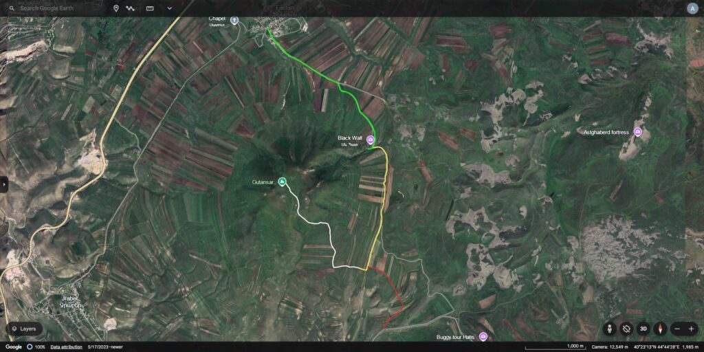
Despite the lack of company, we chose to go together anyway—though to the closest location—Black Wall. We decided to visit it on Sunday, the 15th of September and planned to start our trip early in the morning—at 10. We also wanted to either drive or hike to one of two nearby destinations: an old church in the middle of nowhere and the summit of Mount Gutanasar. While I wanted to drive all the way to one of these two, I had a feeling that the trails would eventually become too much for my car. Not to spoil the rest of my story—but I was right.
The Beginning of the Journey
As Sunday came, I was prepared. I left my house to go pick Mher up at 9:30. Evidently, this was far too early, as I got there at 9:44. Thankfully, he was not only unbothered by this, but also was able to leave about 10 minutes early—saving me that wait.
Having begun early, our journey was off to a good start. We were almost out of the city by 10, with another half-hour remaining to reach our destination. Before going on the dirt, we decided to get a few supplies—in case we were going to be away from civilization for a while. We went to a shockingly upscale supermarket in Charentsavan—one that was nicer than any store I’ve been to in Yerevan. Mher and I got some water and a snack, after which we drove to Fantan—where the road to Black Wall begins.
First Leg of the Trip: Black Wall
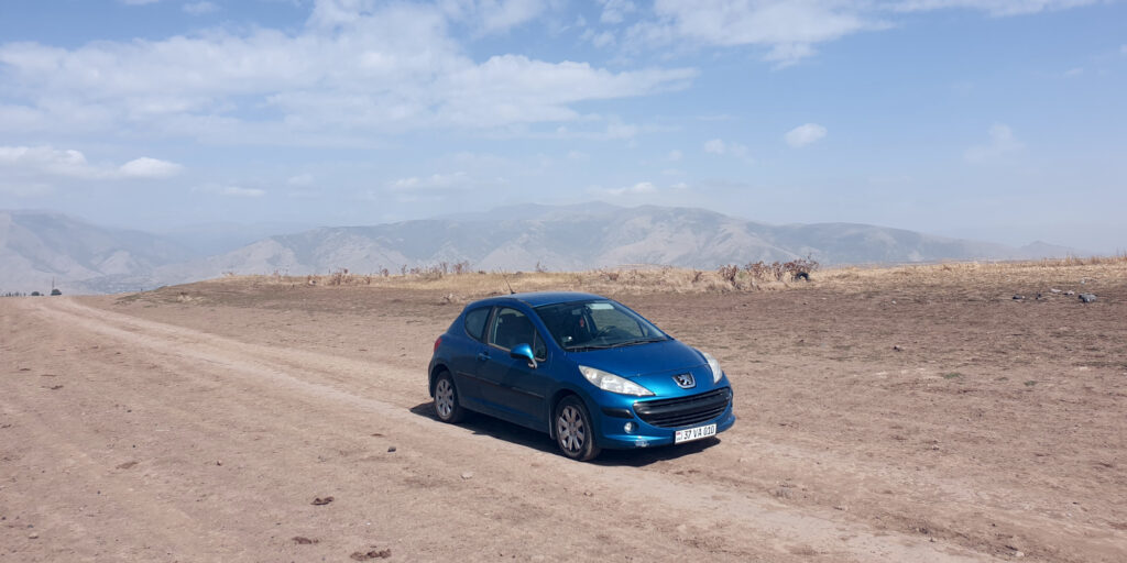
As we got on the dirt road and went up the initial climb, the amazing views of this area were already visible. Naturally, we stopped a few times on flat sections, as I wanted to take pictures of my beloved car. While the photos turned out great, I can only imagine how beautiful the landscape would have been if it was Spring instead of Fall. At least the weather was nice and sunny, though there were some clouds decorating the skies as well.
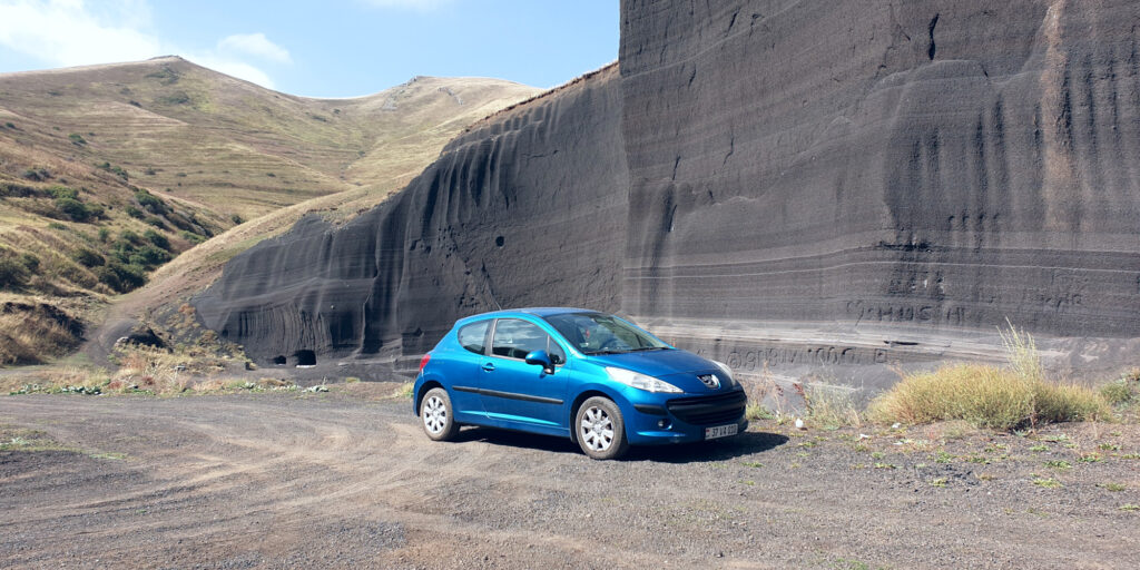
At Black Wall
We arrived at Black Wall with no trouble. Having visited this place before, I knew which lines to take on the trail to make it easy. I took some excellent pictures of the wall—both with my car and without.
While we’re at Black Wall, let me tell you a bit about it. As mentioned before, it is a volcanic formation. It was formed by lava from the nearby dormant volcano—Mount Gutanasar, which last erupted in 200,000 BP. Being more than 200 thousand years old, Black Wall is an ancient site. This undoubtedly contributes to its surreal atmosphere. But, one thing that takes away from it is the wall’s condition.
Unfortunately, Black Wall is not as popular of a destination as some other places in Armenia. Because of this, there isn’t much effort being put in to preserve it. Naturally, some people have started doing the only thing they can do well—ruining it. There are a few engravings on the wall already—of classy things like social handles, no less. But, I suspect as more people go there, the worse it will get. If reading this story inspires you to visit Black Wall—do not carve anything in it, please.
Preparing for the Next Part
Continuing with our adventures, we took a short walk on the trail going out of Black Wall. We went up a short climb to check the trail’s condition and decided to proceed to the nearby church. We got in the car and started the second leg of the trip.
Second Part of the Journey: The Second Destination
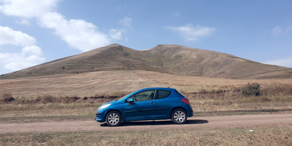
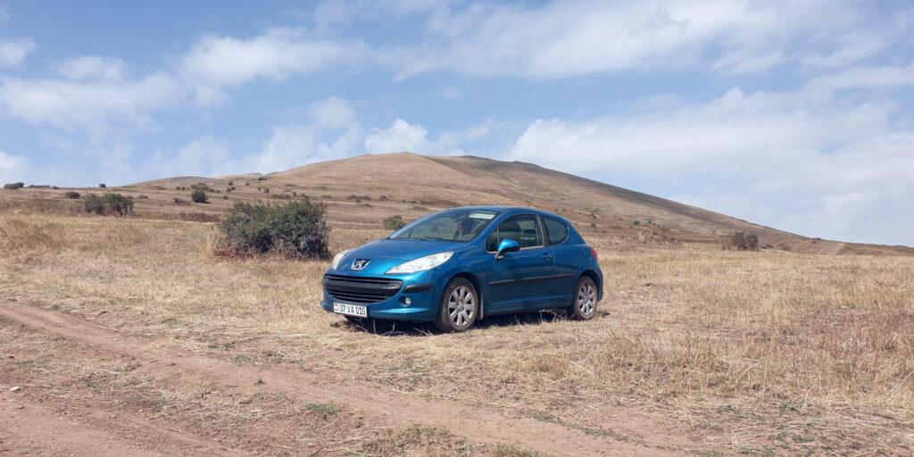
At first, the trail to the nearby church seemed easy. We even had opportunities for some more photos in a few flat sections. But, we quickly faced a huge rut on the road. I didn’t want to risk damaging my car, so we decided to go to the mountain’s top instead.
This trail started out easy as well. But later on, we faced quite a few obstacles. There was a place where the trail’s ruts were too deep and I scraped the underside of my car. Thankfully, it was just tall grass and soft dirt, so no damage was done to any critical components—like the oil pan. To pass this section, I had to place one side of my car on the center of the trail, while the other was off in the grass on the side. The grass was quite tall, which produced a constant scraping noise while driving over it—which was quite unnerving.
As we continued on this trail, we finally reached the point where we had to make a right turn. This would get us on the trail that goes to the top of Mount Gutanasar. But, it is also where the real challenge started.
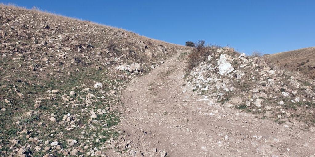
After making the turn and proceeding for a couple hundred meters, I encountered the first scary moment on this trip. There was a hump in the trail with two very inconveniently placed rocks. One was on the left of the trail—protruding into the road just a bit. The other was in the ground and looked to be quite pointy. While I’m not 100% certain about this, I’m pretty sure this was the first time I asked Mher to spot for me.
With his help, I was able to pass this section. Unfortunately for me, though, this success was short-lived. Probably less than a hundred meters up the trail, I started having traction issues. My car is front-wheel-drive after all. It could not cope with the steep climb anymore and was spinning its wheels. Combined with the ground’s increasing lumpiness, this was where we decided it was time for our backup plan—hiking.
Hiking to the Top of Mount Gutanasar
Before we could go up, we needed to come down first. More specifically—I needed to park my car somewhere off the trail. Unfortunately, there was nowhere flat enough for this after the scary rock section. So, with the help of Mher, I reversed past those rocks—three-wheeling at various parts of the descent. A bit further down, I was able to find a spot to turn off the trail and park in a field.
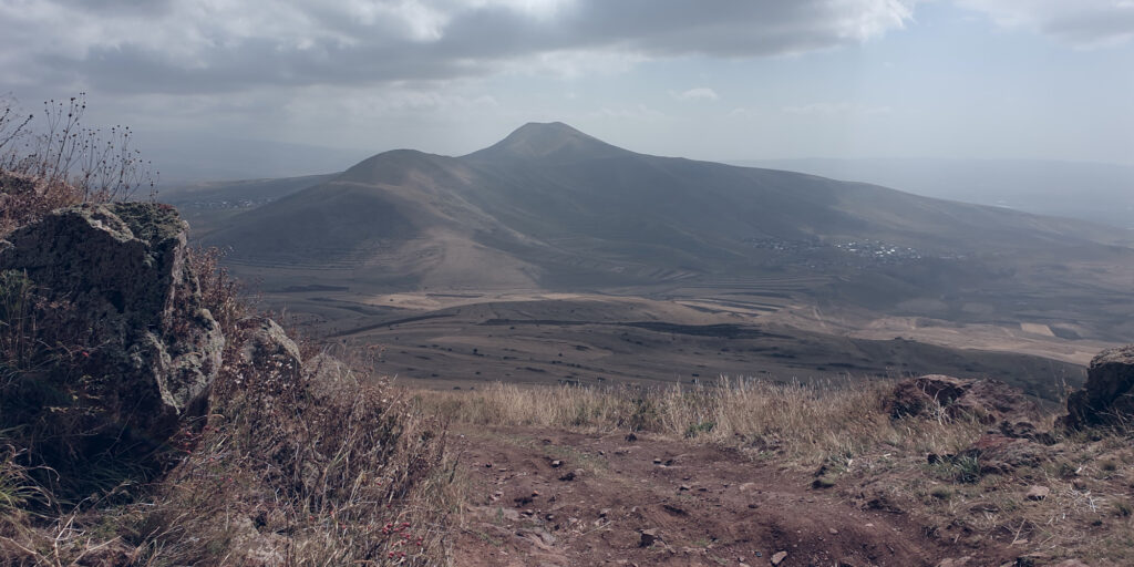
Having safely parked my car, we could finally start our hike. As this is a blog about offroading in vehicles, I won’t talk that much about the hike itself. The key details are that it took us about two hours both ways, though it of course involved a few stops. We harvested some rosehips from a bush and saw the small lake on the mountain’s summit. Unfortunately, the lake was dry, as it only fills up in the spring. But, the views from the top of Gutanasar were amazing. We could even see Black Wall from there, which was a cool experience.
Third Section of the Journey: The Trip Home
After we returned to the car, we set off on our journey home. Initially, we wanted to take the way we came back. But, looking at the map revealed that there was a shorter way. Taking this route would get us on the road that connects several villages at the bottom of Mount Hatis. This wasn’t ideal as it was a slower way home—through multiple settlements, including Abovyan—instead of the highway. But, we didn’t want to go through the obstacles we had already gone over again. So we chose to give the new way a try.
At first, the trail was fine, though it had a lot of grass in the middle. This produced the aforementioned scraping noise, making me quite anxious. But, the real anxiousness started a bit further down, when the trail got too bumpy.
We checked the map once more and found another option, which looked to be even shorter. We hadn’t seen this trail before as it wasn’t as well defined on the satellite image—it probably doesn’t see much use. Then, we turned around—which is always tricky on rutted trails—and headed to the new section’s start.
After we took a right turn on the final piece of dirt road, the ride was surprisingly smooth for a while. There were some tricky bumps. But, with the correct approach, I was able to pass over them with my Peugeot. However, this story’s name contains “rocky trail” for a reason, which we encountered just a few bends away from asphalt.
Going over Rocks with a Stock Peugeot 207
When I saw the rocks embedded in the dirt, I started to panic. The only thing going through my head at this time was how much it would cost to damage something critical here.
An incident in the middle of nowhere would involve far more inconvenience than a traditional one. If I punctured a tire, how would I ever hope to replace it on a jagged slope? If I punched a hole through my oil pan, how would I patch or replace that? Would any tow truck driver even have the will—let alone the ability—to come rescue me?
Learn from my mistakes and think about these things before off-roading a regular car. While it’s really fun, you must be prepared. Research your route thoroughly—including how you’re going to go back. If you made it somewhere on a specific trail, chances are you can make it back as well. Also, if a trail looks rarely used, there’s probably a reason for it.
Returning to our adventurous road trip, I asked Mher to help me through the rocks. After moving a few meters, he enthusiastically said something interesting. Roughly translated— he said, “Look at what engineering work is going to go on here!” Then, he just started throwing loose rocks away from the trail. An obvious move with plenty of benefits, which I probably wouldn’t have come up with in my panic.
How Strategic Rock Relocation Saved the Day
Besides throwing rocks away from the trail, Mher did something even more clever. There was a spot in the ground where there used to be a few rocks next to each other. Most of these rocks were missing, with the sole remaining one being very sharp. Mher simply took a few rocks he was about to throw away and set it down where the missing ones would have been. This allowed me to go over the first sharp rock with no trouble—I couldn’t feel anything when I got on and off it. In total, it probably took us 10-15 minutes to go about a hundred meters.
After we were done with the rocks, there was one last obstacle for us to pass—a very deep and off-camber rut. But, with some more of Mher’s spotting, we were able to finally reach the asphalt.
Reaching the Asphalt and Finishing Up
Getting on the asphalt was a big relief for me. We completed our adventure safely—with nothing more than a bit of scraping on my front bumper’s underside. The rest of the way home was fairly uneventful. We stopped in Abovyan for a quick dinner, walked around the city a bit, and then went home.
While it was stressful at times, I really enjoyed this trip—so much so that I decided to write more than 2,000 words about it. Thank you for reading it, and I hope that my adventures inspire you to explore interesting remote places near you. Just keep in mind that ground clearance and traction are very useful on the trails—and don’t forget to bring a spotter with you!